
Smyrna Neighbors by Block Source
Public records describe different parts of a block. County GIS can place nearby address points in their municipal and emergency-service context. The assessor identifies the person or entity associated with a parcel. Deeds and plats provide a historical land connection, while permits document work at an address. None of those sources creates a complete current household roster.
| Source | What It Shows About a Block | Access |
|---|---|---|
| County GIS address points | Nearby addresses, municipality, ZIP or ZIP4, PSAP, coordinates, and review fields | Public REST layer or map; 2,000-record service limit; not certified |
| Property assessor | Owner, situs and mailing clues, parcel, and characteristics for each parcel | Public county search; query parcels separately |
| Town limits, zoning, subdivisions | Legal town context, zone, subdivision, and urban-growth-boundary context | Public town GIS layers; no person fields |
| Deeds and plats | Adjoining owners, lot or block references, and historical transfers | Register route, counter, and title-search instructions |
| Voter records | A person-level registration match or lawfully released file information | Lookup requires matching details; no block browse |
| Permits and certificates | Address-keyed project and participant information | Town reports or a targeted records request |
Owners and occupants are not interchangeable. A mailing address can be different from the property location, and a public result can be outdated or incomplete. Treat the table as a way to choose the right custodian for a narrow question about Smyrna neighbors.
Map Smyrna Neighbor Parcels
Use the county’s SiteAddressPoint layer to find the target address, then inspect the nearby geometry and address points. Its public fields include address, municipality, ZIP, ZIP4, PSAP, E911 details, address authority, location, subdivision context, and coordinates. A spatial or distance query is available in the REST service metadata, but the exact map-viewer button labels were not established in the research.
- Find or query the target address and write down the parcel, municipality, ZIP, and address-authority clues.
- Identify only the parcels that touch, face, or directly surround the target rather than expanding into a broad area.
- Carry each nearby address or parcel to the assessor and record the result separately.
- Use town zoning and subdivision layers to decide whether a nearby parcel belongs to the same practical block or only the same larger development.
- Recheck a current result and applicable redactions before drawing any conclusion about neighbors.
The REST layer caps a response at 2,000 records. That is another reason to use a small location-focused query instead of attempting a townwide extraction. The map is a geographic lead, not a certified boundary or a neighbor list.
The county address-layer page documents the official GIS fields.
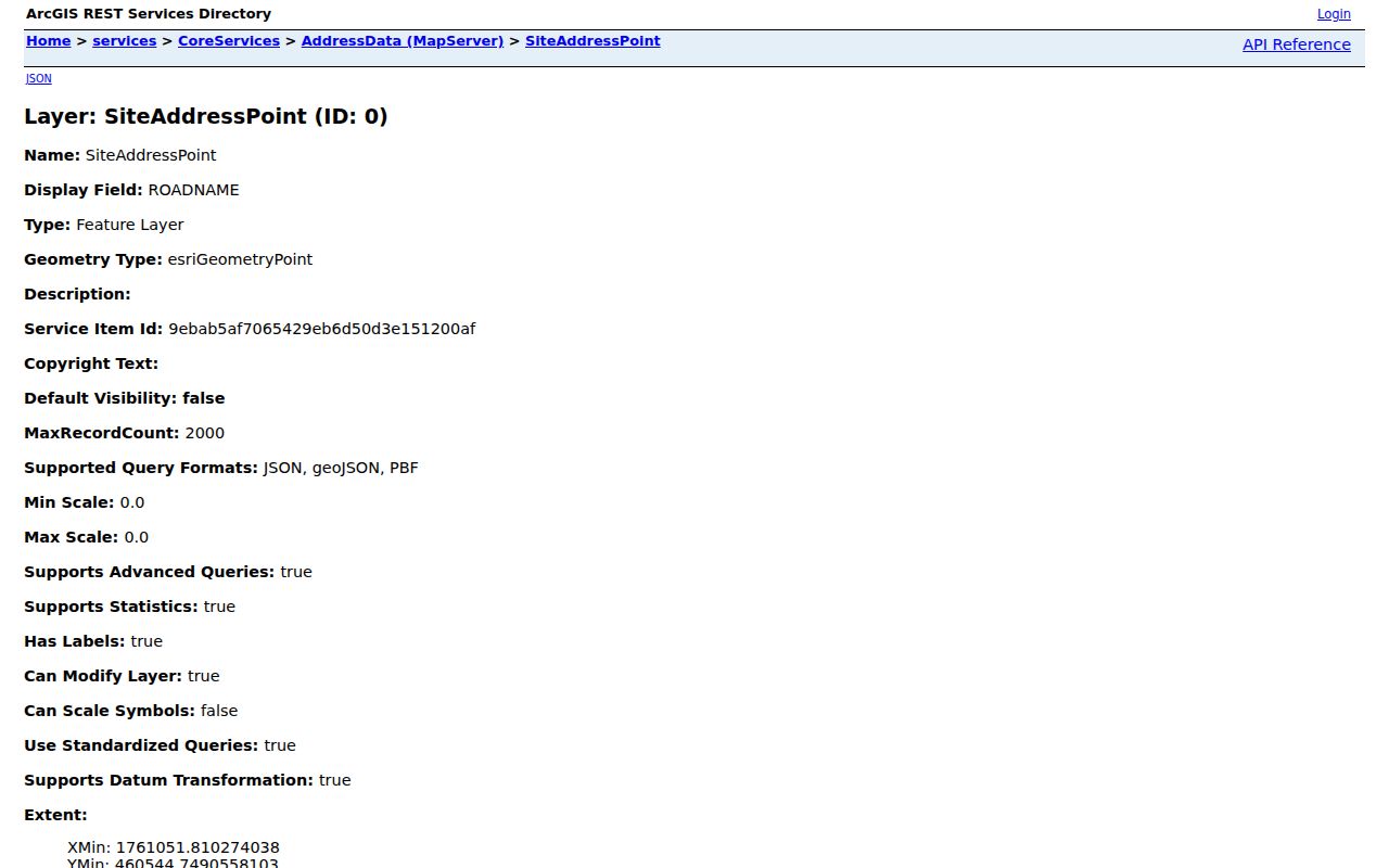
Those fields help separate a street label from the municipality and emergency-service information attached to a particular address.
Check Each Smyrna Parcel
The Rutherford County advanced property search works parcel by parcel. It accepts owner, street, parcel, book or page, building, value, sale, and other filters. Search instructions specify at least three characters; an owner search uses the last name followed by the first name without a comma. Preserve the situs address, mailing address, parcel number, and legal description as separate values.
This individual-parcel approach is more reliable than turning a nearby map point into an identity claim. The current assessor data can show an owner connection, but it does not establish who is living at an address. For a full street-long records trail, use the Smyrna street directory rather than widening a block search without a geographic reason.
The assessor’s advanced-search page displays the parcel and owner filters available for this check.
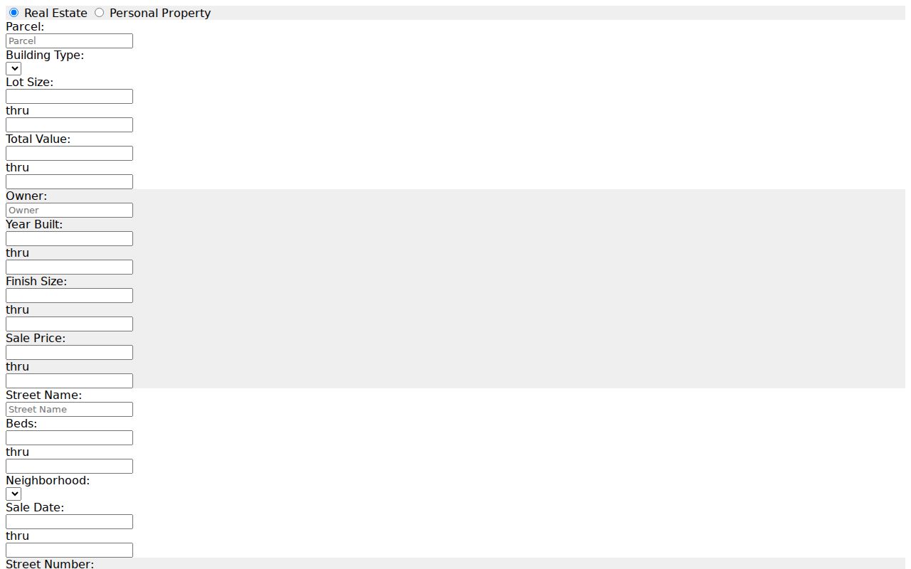
Run the address or parcel one at a time so notes from nearby lots do not merge together.
Smyrna Neighbor Boundary Fields
Smyrna records geography includes a town polygon, county parcel system, urban growth boundary, postal ZIP, municipality code, PSAP, and E911 address authority. The county layer is unusually useful because it returns several of these fields together. A record marked SMYRNA in the municipality field is a different fact from a postal-city label or an emergency-service field.
The Town of Smyrna GIS landing page directs users to town and county mapping resources. Town services include limits, zoning, and subdivision layers. Both town and county materials caution that their maps are not legally binding or certified, so confirm a disputed address with Planning or E911 rather than relying on the screen alone.
The town GIS page is the source for this municipal-layer view.
Check the boundary fields before describing a nearby property as part of the same Smyrna block.
Note: A ZIP code and a town boundary can overlap without being the same geographic area.
Smyrna Deeds and Block Plats
When adjacent parcels need a historical connection, recorded deeds and plats supply the land-record layer. The Rutherford County Register of Deeds holds recorded instruments that can identify grantors, grantees, legal descriptions, derivation clauses, and lot or block references. A plat can place a lot within a recorded subdivision; a deed can show the transfer trail attached to it.
Start with the assessor parcel and legal description. The county’s title-search instructions use map-box, book, and page handling instead of a street-address lookup. Official pages did not expose a definite online grantor-grantee cutoff, so use the Register counter or documented title route when the public web path is incomplete. A land record shows a property interest, not a current neighbor relationship.
Smyrna Neighbor Voter Limits
The Tennessee Voter Lookup is a person-matching form, not a street or block directory. It requires county, first name, last name, birth month, and birth year. The state guidance describes it as a way to confirm a registration record and voting jurisdiction after supplying matching details, not a tool for discovering everyone near an address.
A fuller voter file may be handled by the Rutherford Election Commission under its own statutory acquisition, certification, and use conditions. The research did not locate an official county form, current price, field schema, or export sample. Ask the commission about permitted fields, the file date, protected-voter exclusions, and restrictions before requesting anything. Protected voter information remains outside an ordinary block lookup.
Smyrna Block Permit Reports
Smyrna Building Safety maintains the permit and certificate route, while the Document Center reports page supports filename search and includes year-organized categories. A report can include an address, project type, owner or applicant, contractor, issue date, and certificate information.
Use permits to understand a structure change or date near the target parcel. The accessible material did not establish a complete historical cutoff, and a project participant is not proof of an occupant. For a non-indexed municipal record, name the address, date range, department, and record type in a focused request.
Smyrna Civic Contact Paths
Public community contacts can help a resident find an event, meeting, or local organization without turning a block search into a roster. The town’s planning material names area references such as Paul Johns, Westfork, and Rosenwald Community Center, but it did not provide a complete association directory, boundary list, or member roster. The available contacts are organization-level resources, not household records.
Smyrna Independent Merchants Association
SIMA is an official town-linked civic contact for public local-business and community information.
Rutherford Chamber
The Rutherford Chamber offers public organization contact information for the county area.
No official all-neighborhood-association or HOA directory, joining instructions, boundaries, or membership roster was located. Use a public contact page if one exists for a specific group, and do not infer membership from attendance, an address, or a mention in local news.
Official Sources vs Commercial Neighbor Tools
Official records explain where a data point came from and let a researcher check it with the responsible office. Commercial neighbor-lookup tools may combine data from different dates and sources, but they can carry stale, mismatched, or incomplete information. For a close block question, the first category is the better verification route.
| Official source | Commercial lookup category | Practical difference |
|---|---|---|
| Assessor, GIS, deed, permit, or election custodian | Compiled people-and-address results | Official material identifies the record keeper and record purpose; compiled results may blend dates and identities. |
| Parcel or address-specific check | Broad name or area result | A narrow official query is easier to compare against legal and geographic fields. |
| Custodian correction path | Provider correction process | Ask the responsible office to explain or correct its own record first. |
Use a property owner result, voter confirmation, or permit entry only for the purpose that the record supports. Do not publish or circulate a purported neighbor list based on mixed records.
Request Smyrna Block Records
For municipal material that is not indexed, the Town of Smyrna open-records page points to the town’s request route. Tennessee public-records access depends on the custodian and the record type. A useful request names the department, address, date range, record type, desired fields, and whether inspection or copies are sought.
The town can redact protected information or report that no responsive record exists. A request does not require the custodian to create a new database or answer a broad investigative question. For county material, direct the same narrow description to the appropriate county office rather than sending a general request to several unrelated custodians.
The town open-records page shows the official request path.
A precise request is more likely to reach the office that actually maintains the address-keyed record.
Protecting Smyrna Neighbors
Ownership records do not list every person associated with an address. Utility customer identities, protected voter information, sealed juvenile and adoption material, and confidential Safe at Home addresses have additional protections. The Tennessee Safe at Home program and protected-voter rules mean that a public record search has deliberate limits.
Lawful use. Use Smyrna neighbors records for personal, civic, and geographic questions only. Never use a public record to stalk, harass, intimidate, monitor, or harm another person.